IOnian Sea water quality MOnitoring by Satellite data
Home
Project
The project, approved by the D.G.R. n.115 02/14/2012 , started its technical/scientific activity
on 1st June 2012 .
The main aim of the project is the development of satellite techniques and advanced products
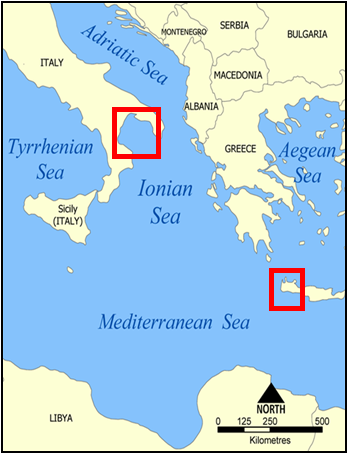
for the study and monitoring of coastal water quality in terms of bio-optical properties, for two test areas:
- Ionian coast of Basilicata region;
- The west coast of the island of Crete.
The changes that has occurred in the last 10-15 years in these areas will be also investigated,
looking for the ones with the greatest level of degradation and those at greatest potential risk. This will allow
to support effective action to protect and safeguard the natural heritage
of Basilicata, in line with OP-ERDF 2007-2013 strategies.
Target groups:
Regione Basilicata: Dipartimento Ambiente Provincia di Matera Comuni del litorale ionico Capitanerie di porto Regioni Puglia e Calabria Enti per la promozione turistica

News and updates
Specific aims of the project are:
- Identification, development and validation of advanced satellite products useful for the characterization
of the coastal waters quality in terms of bio-optical parameters.
- Identification, development and validation of advanced satellite products useful for the study of sea
sediment transport mechanisms.
- Multi-year trend analysis (up to 15 years) to identify the areas most degraded and/or those at greater potential risk.
The Robust Satellite Techniques (RST-Tramutoli, 2005)
approach will be used in the project. RST is a general methodology for multi-temporal satellite data analysis proposed by
SI-UNIBAS and
IMAA researchers.
This approach provides a preliminary characterization of the investigated signal in terms of expected value and
natural variability in specific observation conditions, through the analysis of historical satellite
data/products. Statistically significant deviations of the signal investigated
from these values are subsequently identified as anomalies in the spatiotemporal domain,
which can then be attributed to natural or anthropogenic causes.
In order to implement RST for the project purpose, multi-year time series of ocean color products will be analyzed
In particular, the products generated from SeaWiFS
(Sea -viewing Wide Field -of -view Sensor) and MODIS (Moderate Resolution Imaging Spectroradiometer) observations, will be used.
These products are generated with a spatial resolution of 1km and a daily temporal resolution.
For both of them, more than ten years of satellite observations are available.
The satellite data available at the IMAA and SI-UniBas archives will be also analyzed for the generation of original products
concerning water quality parameters. This will allow the use of data even at higher spatial resolution (250m) and
temporal resolutions of up to a few hours.
All the products will be developed and validated thanks to adequate measurement campaigns (both ground- and air-based) carried out in
the test area.
Finally, the multi-temporal analysis of satellite products/data at high temporal resolution (up to 15 minutes),
will provide an indication on their ability to give information about the phenomena of sea suspended material transport
(sediments, mucilage) and their dynamics. For this analysis, in addition to the data mentioned above,
those acquired by SEVIRI (Spinning Enhanced Visible and Infrared Imager),
the multi-spectral sensor on board of European satellite "Meteosat Second Generation (MSG)" since 2004, will be used.
The analysis of anomalies in the space-time domain in addition to the trends analysis of investigated parameters, will allow
the identification on the products that best correlate with the phenomena (eg. pollution/degradation ) and the dynamics of
environmental interest.
O.1. Aggregated (weekly and monthly) maps of satellite bio-optical parameters relevant for the assessment of water quality (eg Transparency, Contents of Chlorophyll-a, CDOM - Colored Dissolved Organic Matter, SST-Sea Surface Temperatures, TSM - Total Suspended Material)
O.2. Maps of space/time anomalies in the historical series of O.1.
O.3. Maps of probability/frequency of anomalies occurrence referred to O.2.
O.4. Mapping of the areas with the greatest degradation level and those at higher potential risk through the integration of the outputs O.2 and O.3.
O.5. Analysis (report) of the transport dynamics and of the main sources of degradation/pollution identifiable by satellite observations.
O.6. Analysis (report) of the sediment transport dynamics released at the mouth of the major rivers during extreme weather events.
O.7. Calibration and sensitivity analysis of satellite products through in-situ and airborne measurements.
A lot of important tourist and commercial activities take place in the Ionian coast of Basilicata region
whose sustainability depends heavily on our ability to preserve the quality of the natural environment and, in particular, of the coastal marine ecosystem.
The project will enable the Basilicata Region to acquire advanced satellite tools for the study and monitoring of the status of water quality in this area.
The expected impacts will affect not only the growth of knowledge on the historical evolution of the main degradation cases, but also the possibility of seeking effective instruments
sustainable over time, for continuous monitoring (with updates from a few hours to a few minutes) of coastal territory. In this way the activities of defense and/or mitigation of damages,
will be supported, with direct benefit to the citizens and to the quality of the local tourism.