IOnian Sea water quality MOnitoring by Satellite data
Component 2
Planning and implementation of measurement campaigns and calibration with airborne and in-situ data
The activity will consist in the planning and implementation of three in-situ measurement campaigns, and (at least) one
airborne-based for the calibration/validation of satellite parameters of interest.
The preliminary phase will consist in
identifying the pilot area; after that the measurement step will be carried out. During the campaigns different data will be acquired using different
technologies, such as: water sampling for lab analysis, spectro-photoradiometric collections and radiances measurements.
2nd measurement campaign
3rd measurement campaign
4th measurement campaign
5th measurement campaign
Responsible partner:
CNR - IMAA

Identification of the pilot area
The choice of the areas should be made on the basis of the interactions between stakeholders and users.
The choice must take into account the site relevance in relation to coastal issues.
Planning of the measurement campaign
Planning must take into account the characteristics of the identified remote data and the available instrumentation, in order to
optimize the acquisition allowing the concurrently in-situ and remotely sensed data measurement. Three measurement campaigns have been planned,
they will be carried out at different times of the year to get an idea of the seasonal variation of the investigated parameters; also one (at least) airborne
airborne-based campaign was planned with the aim of calibrate/validate the models for the interpretation of remote data. The exact number of measurement sites
and their location should be determined only after the test area choice, depending on its specific characteristics. Acquired data must be
representative of different types of water (i.e., case 1 and case 2 waters). The number of expected fixed locations
(same location in the various measurement campaigns) ranges from 5 to 10 plus a limited number (1-3) of measurement sites that
will be positioned according to specific needs. Ten to fiftheen hours of flight hours will be done, according to the available budget.
Realization of the measurement campaign
The measurement phase must ensure the availability of EO/not EO information necessary for the calibration/validation of the parameters of interest,
and eventually the calibration of algorithms/proprietary modules.
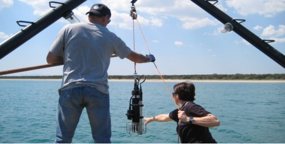
The main data to be acquired during in-situ measurements will be:
- radiometric measurements for the spectral characterization of the water body and eventually of the in-water vegetation using the
portable spectro-radiometer;
- water samples for laboratory measurements of chlorophyll concentration(Chl-a), particulate matter (TSM) and dissolved substance (CDOM)
and its optical properties (absorption and scattering); these analyses will be carried out according to the SeaWiFS protocols.
Such measurements are necessary for the development of models and algorithms suitable to interpret the remote data
- ancillary data such as wind speed, state of the air/water surface, pressure, temperature and salinity of the water.
By airborne:
- hyperspectral measurements in the visible and thermal infrared region of the electromagnetic spectrum.
- 1 Implementation plan about the realization of in-situ measurement campaign (18-19 April 2013).
- 1 Implementation plan about the realization of in-situ and airborne measurement campaigns (15-16 July 2013).
- 1 Implementation plan about the realization of in-situ measurement campaign (1-2 July 2014).
The documentation produced and to be produced relative to the second component is the following:
- 1 Report about the implementation of the in-situ measurement campaign (18-19 April 2013).
- 1 Report about the implementation of the in-situ measurement campaign (15-16 July 2013).
- 1 Report about the implementation of the airborne measurement campaign (15-16 July 2013).